Showing posts with label sunrise. Show all posts

Tuesday, November 22, 2016

Photographing Bryce Canyon National Park

First Visit


Sunset Point Detail
As I indicated in my previous post, my first trip to Bryce Canyon National Park in November, 2016, did not go quite as planned due to my Ford Explorer transmission failing. As a result, even though I spent almost a week in the area (at Panguitch, Utah) I ended up only spending about 2 and a half hours at Bryce Canyon National Park.

I did not visit all of the view points. I did not even drive to the end of UT 63, the road through the park. I visited the visitors center, the Sunset, Bryce, and Inspiration view points, and North Campground. My sample of the park is limited.

Photographing at Sunset


As I discovered while researching the park before my visit, Bryce Canyon mainly runs north and south. The park is located on the west rim of the canyon. This means that, from the view points, sunrise is probably the better time to take photographs. My short visit was at sunset.

Sun Setting at Sunset Point
At sunset time there can be a lot of shaded area and because the cool hoodoos are mainly close to the west rim, they can be in shadow when the eastern part of the canyon is still lit. You can see this in the photograph at right.

This  makes the photographs hard to post process and basically not terribly attractive. The red of the hoodoos just isn't as spectacular as when they're lit directly. And, as in the picture at right, the near hoodoos are more striking than the distant landscape and should be the focus of the image however, due to them being in shadow, they really don't command the attention in the photograph.

One solution is to crop out the lit areas or to not include them in the crop at exposure time. Another reason to use a longer lens for landscape photography. The crop of the photograph at the top of the page is somewhat different - I was able to get the interesting formations while they were still lit by the sun and to include the "bank" behind them which was in shadow. I'm happier with that composition.

My Favorite View Point

Again, my time at Bryce was limited. But out of the 3 viewpoints I stopped at around sunset, Inspiration Point was my favorite. I felt it provided a nice place to fill the image with hoodoos.

Shot from Inspiration Point

This shot might actually be better in mid-day light. This shot is basically looking north from the view point, perhaps 5 or 10 degrees east of north. I didn't see it at sunrise so I can't say for sure how it would look, but the sun would be hitting the right side of the hoodoos. Perhaps during the winter months the sun rises far enough to the south that it might get more direct sun as it rises.

What's Next?


I definitely want to go back when I am not focusing on my automobile issues. I want to see all of the viewpoints, including the Natural Bridge. From the rim, all photographs have a perspective of looking down at the hoodoos. All of the shots I took are very similar, at least from that perspective. I think you need to hike down into the canyon a bit to get different perspectives.

I think there are probably a lot of good photography opportunities there, and I know it is a destination for a lot of photographers. Personally I didn't find much diversity. Yes, it's different than a lot of other areas but it just struck me that there is really only one subject - the red hoodoos.

Frankly, I think I got spoiled by Yosemite and Sequoia / King's Canyon National Parks. I really like the diversity of subjects at Yosemite - the granite, the valleys, and the rivers and water falls. I had the same lack of enthusiasm at the North Rim of the Grand Canyon in October, although I did get to shoot some bison photographs there. I'm trying to keep my enthusiasm up for non-Yosemite landscapes!


Monday, November 21, 2016

Bryce Canyon National Park - Postmortem

I'm Back - Finally!


A selfie at Bryce Canyon National Park
I made it to Bryce Canyon National Park and back but not without some issues...

Per my plan, I headed up to Utah on Friday, November 11, 2016. I expected to just be gone over the 3 day weekend, returning home on Sunday, November 13, 2016. I left Phoenix at about 2:30 AM after filling up with fuel and coffee, expecting to arrive 7 to 8 hours later at Bryce Canyon National Park. I half planned to try to get some sunrise shots along the way if I was somewhere that I thought might be interesting.

I use about a half a tank of fuel in my Explorer to get to Flagstaff so stopped there about 2 hours later to top off the tank and grab another coffee. It was about 25 degrees Fahrenheit when I got out of the Explorer in Flagstaff - that helped wake me up!

Lake Powell Wahweap Overlook


Wahweap Overlook at sunrise
As I headed on up the road it was looking like I'd hit Page and Lake Powell about sunrise. I pulled off the highway to visit the Lake Powell - Wahweap Overlook. I'd tried to go up there a year ago but as I turned on to the road on that visit, my cooler tipped over in the back of my Explorer. Fortunately my sleeping bag was laid out so it soaked up all of the melted ice water! Anyway, I ended up taking care of that mess and never did get up to the overlook.

This time I did go up there, hitting it before the sun broke over the horizon.

I was disappointed in the location. The view of the lake isn't great from there. The main body of water has the Wahweap Marina in it and it just wasn't that pretty to me. At this time of year (November), the sun is rising in the south-east which means you're shooting towards the Salt River Project-Navajo Generating Station and it's tall stacks. Another feature I don't care to take photographs of.

But, I did get a sunrise shot using my 70-200mm lens so that I could narrow my field of view. However, I really wanted a sunburst but forgot to close down the aperture to f/22. So, here's what I got:

Sunrise over Lake Powell

On to Bryce Canyon National Park?

I headed on up the road, passing in to Utah along U.S. 89. I drove through to Kanab, UT where I again filled up the fuel tank and grabbed another coffee and some Pop Tarts. The next stop I planned on was at Bryce Canyon National Park, about an hour and a half from Kanab.

From U.S. 89 you need to turn east on UT 12, which leads to UT 63, the main road through the park. Before I got to the UT 12 turnoff my Explorer started running rough. I turned on to UT 12 and drove through the Red Canyon and made it to the Chevron / Bryce Canyon Pines General Store at mile marker 10, where I pulled in.

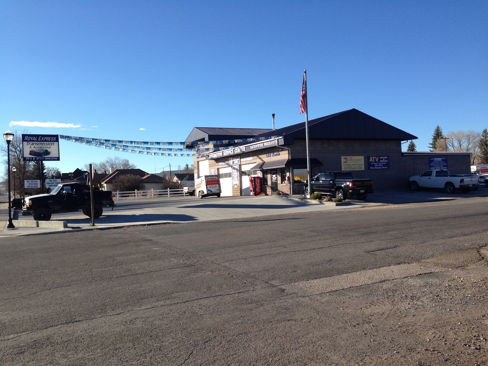
Royal Express Automotive
I decided I better head back to Kanab but when I tried to leave the Chevron I couldn't make it up the very slight incline. I had to do a 3 or 4 point turn on UT 12 because there is not much of a shoulder along the road there, and then made it back to the Chevron parking lot.

After some time, and with my wife working on things from Phoenix, we arranged for a tow (through our auto insurance, State Farm), to Panguitch, UT where there is a transmission shop. Eventually, after a couple of hours, I arrived at Royal Express Automotive.

It turned out my transmission was shot. I ended up staying in Panguitch until the following Thursday before it was replaced. I got my Explorer back at about 3:00 PM on Thursday, November 17, 2016. 

Off to Bryce Canyon National Park - for reals


I had hoped to get the Explorer back by 11:00 AM or so, and then to at least do a drive by on my way back to Phoenix. While I was waiting at the auto shop, I struck up a conversation with a woman who turned out to be the wife of a ranger at Bryce Canyon National Park. She convinced me that I should visit it as long as I was this close. So, after getting the Explorer and its new transmission, I headed there.

It was very cold - my Explorer said 21 degrees Fahrenheit - and pretty windy. Everyone was bundled up. I first went in to the Visitor Center to get my National Park Passport cancellation stamp and picked up a couple of souvenirs.

Then I visited Sunset Point, Bryce Point, and Inspiration Point. The sun was pretty low in the sky and the shots weren't that exciting. The scenery was nice but it was so cold that it was miserable to be out on the viewpoints to take it in. I tried, and I took a few shots, but damn it was cold!

I toyed with staying overnight but I thought I'd seen a weather prediction of temperatures getting to about 6 or 7 degrees Fahrenheit and I just couldn't bring myself to going through that after the week I'd spent already. So I settled for a few shots with the intent on visiting again, hopefully when it is a bit warmer!

Sunset Point Detail


Saturday, August 29, 2015

My 2015 Vacation, Part 6 of 7

I woke up sometime around 5:30 AM on 8/5/2015, as the sun was making itself known. I had slept really well in the back of the Exploder, and really was happy with the REI self inflating sleeping pad. I had zero complaints about my sleeping arrangements, unlike when I previously used simple foam pads. I got up, walked to the bathroom, returned and re-arranged the inside of the Exploder, had a breakfast bar, and started my day.

I had reserved a campsite for the day at Cape Lookout State Park, about 81 miles north. According to Google it’s about a 2 hour drive and I had the entire day to do it. Cool! That should leave some time for taking some pictures.

Path to the Pacific at Beachside State Recreation Site
I started by snapping a few iPhone pictures of my campsite at Beachside State Recreation Site with the iPhone. My site was maybe 50 yards from a beach access path, which opened almost directly on to the Pacific and its constant and reassuring gentle roar of the surf. I took the pics but didn’t actually walk on to the sand. As much as I like being at the coast I really am not a big fan of being on the sandy beaches or dunes.

I fired up the Exploder and headed her north along the Oregon Coast Highway (Highway 101) with the sky starting to lighten.

As I came to the Alsea River and crossed the Alsea Bay Bridge at Waldport, the sun was beginning to show above the horizon. I noticed that there was a jetty to the west of the bridge and it occurred to me that there could be a shot of the sun coming up over the bridge just waiting for some tourist that took the time to drive over there.

I looked at Jill the GPS and tried to figure out how to get over there. On my second attempt, after hitting a dead end, I was cruising through the Bayshore area. There are a lot of houses there and pretty much the entire eastern waterfront is private property except for one vacant lot. I drove onto the lot, grabbed my Nikon D610, 50mm lens, and Manfrotto tripod and scurried to the edge of the water.


Alsea Bay Bridge at Waldport
I got set up as the sun was already up over the bridge and realized I couldn’t frame the entire bridge with the 50mm. I didn’t have time to go back and get the wide angle lens, though, so I shot with what I had. I like the results but wish I’d had the wide angle lens. I would really like to go back and try that shot again using the wider lens. Thank you to the residents for leaving the vacant lot, and thank you to the powers that be for a nice image to start my day!

I headed on up the road, until stopping off at Seal Rock State Wayside again. Actually, I stopped at the pull off at Little Creek, just south of NW Cross Street. I got out the Nikon again and took a lot of pictures of the waves hitting the rocks there. I really wanted some sort of wave action and this was about as good as I was going to get in the middle of summer.

I continued up to Newport where I paid another visit to the McDonalds for breakfast and coffee. I took advantage of their free WiFi and uploaded some posts to Facebook, called my wife, and brushed my teeth in the parking lot. Okay, I didn’t need WiFi to brush my teeth.


Yaquina Head Lighthouse
I drove up to Yaquina Head Lighthouse, arriving there about 8:00 AM. I was too late for the golden hour but the sun was still fairly low on the horizon and providing some nice side light. I got some pictures of the lighthouse, the seals on the rocks at Yaquina Head Marine Garden from up above (you can walk down to the rocks), and from the north side of Yaquina Head. I saw some whales spouting but couldn’t really get a picture of them. What a glorious morning it was there! I could easily have taken a position as a lighthouse keeper there!

I did think to myself that I could have used a longer lens while shooting the seals on the rocks. If I’d gone down the path it would certainly have got me closer but I would have lost the perspective of the shot from above. I have a personal philosophy that I don’t buy things just because I think they’d be nice to have, but if they’re somewhat expensive at all and I’m skeptical at all about how much I’d use them I wait until I think I could have actually used the item at least twice before I spend the bucks. This makes occurrence number one for a longer lens (like the Sigma 150 to 600).

After some amount of time at Yaquina Head, I continued on my way north. I drove past Beverly Beach State Park and recognized it as the last place I went camping for many years. My first wife and I camped there in the late 1970’s on our Honda Goldwing. We woke up to rain. The tent and sleeping bags were soaked. We had to crawl out of the small tent (the Goldwing didn’t allow us to take a huge tent) into mud. We had to drive about 120 miles from there to our home in Portland in the rain, soaked and muddy. I didn’t camp again after that until the late 1990’s when my third wife and I started fishing and camping at Detroit Lake in Oregon.

Looking south from Otter Crest Wayside
I made my next stop at Otter Crest State Wayside and the Cape Foul Weather gift shop at about 10:30AM. This is a cute little gift shop perched on the side of a cliff at about 450 feet above sea level. People inside were taking advantage of the whale viewing. I picked up some souvenirs for my wife, a few co-workers, and myself. I took some pics with the iPhone and settled for them without getting a Nikon out. 

After bit more driving I got to Depoe Bay, Oregon at about 11:00 AM. I have always enjoyed Depoe Bay; it resonates with me for some reason. It’s probably my favorite town on the Oregon coast. This was the first time, however, that I actually drove much off of the main highway. With Jill’s guidance I drove to the east side of the bay, past the Coast Guard station, and found a place to park near the marina. I got out and walked around, taking some iPhone pictures of the activity there – people returning from their morning charters were having their fish cleaned. It was a very busy area, people going to and fro, children playing, the smell of the ocean and fish being cleaned, perhaps even some fish tales being told! If I could have a job there I’d have stayed without any hesitation. It made me think of my son and his commercial fishing. I wonder what people must have thought when they saw me walking around with a grin on my face!?

The bridge and marina at Depoe Bay
From there I decided to stop at Boiler Bay State Scenic Viewpoint. I did try some pics with the Nikon there, wanting them to be interesting, but my wanting didn’t make it so. By now the sun was pretty much overhead at about noon, and there really wasn’t much to take a picture of besides the rocks themselves. The best subject were some people fishing on the rocks but even that didn’t seem great. This place is nice when there are heavy swells crashing, mainly in winter, but on the day I was there it was a pleasant summer day, nice in its own right, just not for photographs.

I headed back to Depoe Bay to grab some food at the Sea Hag Restaurant. It’s a place I’ve gone to for years and I’ll always remember taking my kids there. I think the last time we went there we got a bucket of oysters. I just had a wonderful, fresh, cod fish and chips, with a bowl of clam chowder. Yum. Then I got a bag of salt water taffy for my wife before taking some more iPhone pictures and heading north again.


Looking north at Netarts Spit
I travelled through Lincoln City where I fueled up, past the intersection with Highway 18 which leads to Portland through McMinnville and Newberg, where I’d be in a week or so. I continued to Neskowin and then exited Highway 101 onto Brooten Road, passing through Pacific City, and following the road until taking a left on Cape Lookout Road.

I stopped at the pull out that overlooks the Netarts Spit, the base of which is where Cape Lookout State Park campground is located. The overlook is about 325 feet above sea level and gives a nice view of the spit from the south. I tooks some pictures with the iPhone - had to post to Facebook to make everyone that I knew on Facebook who wasn't there with me a bit jealous. Especially the Arizona folks. The Oregonians could get there in a few hours.

I continued on down the hill to the campground and checked in. It was late afternoon and I decided I would put up the tent this time but I wanted to do it before it was dark. I got the camp set up about 5:00 PM and then decided to head on up to Oceanside and Cape Mears.

Cape Mears Lighthouse
There is a small lighthouse at Cape Mears. It's a short walk from the parking lot, perhaps 1/4 of a mile. Note that it is downhill from the parking lot. Going back is a bit more of a chore. There are two paths from the parking lot and both of them have benches along the path so that you can stop and rest on the way up, or stop and enjoy the scenery. This light house is tough to get a good picture of due to the small size of the grounds where it is located and the likelihood of other visitors that will be in the picture.

From there I decided to find something for dinner. I went in to Oceanside but the only thing I could find was a good sized diner and I wasn't really interested in a big meal. I just wanted a cheap gas station sandwich but there aren't any gas stations in Oceanside. I punched "grocery store" in to Jill the GPS and she claimed to find one. When I got there it was an old, closed up building. The next nearest store was in Tillamook so off I went.

I got to Safeway but instead of getting a cold sandwich I bought a couple of pieces of their hot deli chicken and some potato wedges. I already had my own water. I ate in the Exploder while posting some things in the Safeway parking lot. There hadn't been any cell phone reception out on the beach. I watched a cute girl in a car with California plates pull up in front of me and sit a few minutes before a guy pulled up in a car with Oregon plates. She got in his car and they drove off.

When I was done I headed back to Oceanside and located a public parking lot with beach access. I chatted a while with a guy driving a motorcycle who was sitting on a fence playing his acoustic guitar he'd brought with him. He was from a bit of a distance (I think he said he was from Salem) and had gone out for a quick ride but ended up at Oceanside.

Oceanside, Oregon

Oceanside is a cute little town situated mainly on a hillside facing southwest overlooking the Pacific. What a pretty place to live if you can. Even visiting was nice. But the coolest thing are the Three Arch Rocks National Wildlife Refuge just off shore from Oceanside. In the summer months the sunset can be lined up between the rocks making for a great sunset photo.

I took the D610 and tripod down to the actual sand. The wind was blowing a bit but not kicking up sand. I got some very nice pictures there with both the Nikon and the iPhone. There were kids on the beach flying kites and I was worried at first that they'd ruin the shot but when I was composing through the viewfinder I found I actually preferred the shot when they were in it. I got plenty of both!

Three Arch Rocks National Wildlife Refuge


After the sun disappeared I made my way back up the beach to the Exploder and then back to my campsite. I got there in near dark. I decided to pour a few ounces of Johnny Walker, reviewed the pics on my cell phone and Nikon as I had a drink, then went to bed and again slept like a babe!

Click here for the next installment...