Showing posts with label California. Show all posts

Friday, December 16, 2016

Reflections of 2016

Looking at 2016


I just received an award at my day job yesterday for being an employee for 15 years. It is near the end of the calendar year. Both of these events have caused me to reflect on this last year of 2016.

My DJI Phantom 3 Advanced
I spent a lot of time this past year dealing with health issues. Nothing too terrible, just sinus infections including Allergic Fungal Sinusitis, a nasty little collection of issues that resulted in a lot of down time and 3 surgeries.

At the beginning of the year I added a DJI Phantom 3 Advanced to my photography kit. I wanted to like it but ended up being very disappointed with the still image quality to the point that I am selling it. The video capabilities might be fun for some but I am not looking to do video. The still images are barely useful for posting on social media in my opinion.

I also don't like flying the thing. I got it after it went on sale at the beginning of the year for about $800 for the basic drone but it's still too much money for me to want to lose by running it in to something. It's just not for me.

Arizona's Raptor Experience 


Luna the barn owl
Arizona's Raptor Experience
I didn't really get out to shoot photography until May when I visited the Arizona's Raptor Experience in Chino Valley, Arizona, with a fellow shipmate from my last Navy ship, the USS Paul F. Foster DD-964 where we served together for such fun deployments as the first gulf war.

We spent a few hours shooting various raptors as the owners placed them on various features such as stumps which they had staged around their grounds. It was pretty amazing! I got a few shots that I liked, but the ones of the Harris Hawk in flight made me realize I don't have much practice or skill at capturing birds in flight!
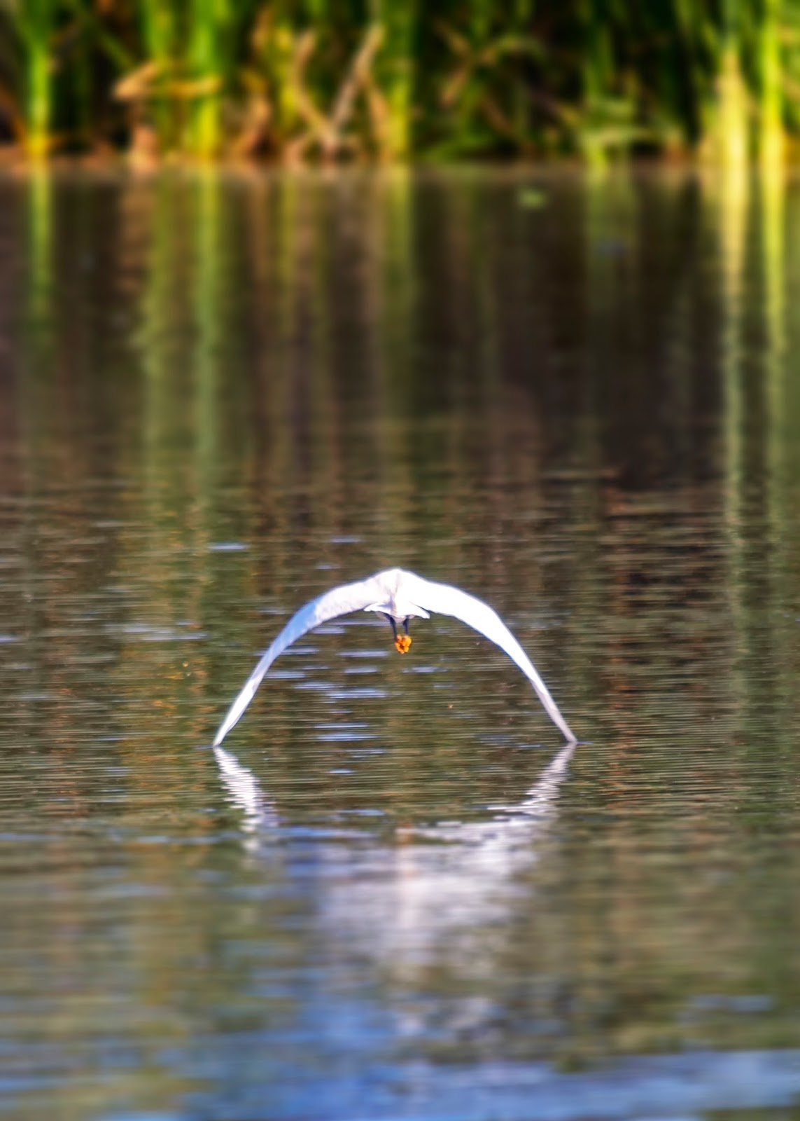
Snowy Egret at Gilbert Riparian Preserve
Gilbert, Arizona
I did get this image of a snowy egret at the Gilbert Riparian Preserve in Gilbert, Arizona, which is my best shot of a bird in flight to date.

My birding experiences made me realize that I really wanted a longer lens. After reviewing the Sigma, Tamron, and Nikon lenses, I chose the AF-S NIKKOR 200-500mm f/5.6E ED VR. I didn't get out and try it much until later in the year...

In May I also dovetailed in a 1 night excursion  to the Chiricahua National Monument to shoot the Milky Way. I got a decent capture of it and enjoyed my overnight trip.

And, in May, I squeezed in a very short and unproductive visit to Saguaro National Park near Tucson, Arizona. Unfortunately I was only there during mid-day and did not even bother taking any photographs.

After my birding excursions I had a couple of surgeries and during the recovery (as well as a lot of the entire year) I spent my down time reading John Muir books which generated a great desire to visit Yosemite National Park. I put in a request for vacation for the first week of September, following the Labor Day weekend (a holiday for most people in the United States).

California Here I Come


I stayed in 3 California parks: Joshua Tree for one night, Yosemite for 3 nights, and Sequoia for 1 night. I got some shots that I like a bit but I know I could do better so I'm planning to head back sometime. I really want to get back to Yosemite in the early spring in order to try to get some photographs of snow on the ground. And, when I was there in early September, there was very little water in the falls. Yosemite falls was non-existent.


Moon over Joshua Tree National Park, California
Half Dome and El Capitan
Yosemite National Park, California
Sequoia at Sunrise
Sequoia National Park, California

More Parks for Me!


After I got home from my California parks, I was still feeling good (must have been the steroids I was on!) so I decided to take a day trip with my wife and our dogs up to Sunset Crater Volcano National Monument and Waputki National Monument, both near Flagstaff, Arizona. After she saw that, I talked her into spending a couple of nights at the North Rim of Grand Canyon National Park.

Sunset in Ruins
Waputki National Monument
Arizona

We went to the North Rim of the Grand Canyon for another 3-day holiday weekend for Columbus Day. I got a couple of shots of the canyon that I like but I also got some shots of wild bison that captured a wonderful experience of sitting on the ground  a few feet in front of wild and un-caged bison!


Sunrise at Walhalla Overlook
North Rim Grand Canyon National Park
Arizona

Wild Bison
North Rim Grand Canyon National Park
Arizona
And finally, not wanting to be done for the year, I decided to visit Utah's Bryce Canyon National Park over the Veteran's Day 3-day weekend in November. This trip ended up with the transmission on my Ford Explorer giving out so my visit at the actual park was cut short but I got a shot or two that I like. 

Sunset at Sunset Point
Bryce Canyon National Park
Utah

Six National Parks in 2016


The year's not quite over but I'm not sure if I'll get to any more National Parks before the end of the year. I've got half a notion to try to get to the Petrified Forest National Park but we'll see if I make it. Regardless, I visited 5 National Parks and 3 National Monuments this year that I had never been to before (I visited the North Rim of the Grand Canyon in 2015). 

In every park I got to see something that was new and amazing. There were always photography opportunities that challenged my artistic eye and photographic abilities. Some places actually took my breath away when dealing with the view or the heights or the bison.

Besides the bison, I got to see some other wonderful animals in their natural habitats which is much better than a zoo. I had some medical issues to contend with but it ended up making me appreciate the times that I got out even that much more and makes my photographs more personal as well since they captured what I was able to see and do in 2016. I hope your year was good for you too!

Thursday, October 27, 2016

My Favorite National Park

I've been Everywhere


Me on the USS Rogers in the Straits of Juan de Fuca
Olympic National Park and Port Angeles, WA
Ca. 1977
Okay, that's a bit of an obvious exaggeration. I've been a number of places on the west coast of the United States and a few places beyond. I went through my grade school and high school years on the Olympic Peninsula and often went camping or visiting around the Pacific Northwest, including innumerable visits to the Olympic National Park and Hurricane Ridge. 

In the Navy I visited overseas to Hong Kong, the Philippines, Singapore, Thailand, and Australia, to name a few places.

I've definitely been to Yosemite National Park


Seven weeks ago I visited Yosemite National Park for the first time. I spent three nights there, two full days and parts of two more days. I drove most of the paved roads in the park. I drove from the east entrance to the valley, from the valley to Hetch Hetchy, Glacier Point, and to the south entrance. 

I walked a little bit in the park (I wish it was more). I smelled the smells, felt the Merced and Tulomne river water, laid on some granite near Tenaya Lake, sat in El Capitan meadow and climbed some rocks at the base of El Capitan (just some of the ones laying at the base - no cliff climbing!).

Out of my (this is just between us) 59 years on the planet I've spent less that four days total at Yosemite. So why do I miss it so much?

Withdrawals


Yosemite Valley from Tunnel View
This is the U.S. National Park systems centennial anniversary. As part of their promotion they want us to determine our favorite park. I have to say that mine is Yosemite.

I've been through a divorce. In fact, two of them. When I was separated from my wives and children I missed them and would find myself thinking of them all of a sudden, "out of the blue." During the last seven weeks I've had the same experience with Yosemite. I woke up this morning after some insignificant dreams but as soon as my alarm went off I had a vision of looking at Yosemite Valley from Tunnel View which then fed into a vision of walking along the trail at the base of El Capitan. 

I have similar visions every day. One minute I'm on the shore of Tenaya Lake, the next I'm at Washburn Point. I find my mind drifts off...

Last Friday my wife and I went out to dinner. She was talking about something that I'm sure was very important. My mind was examining a vision of Half Dome and I was wishing I could get closer to the mountain.

A couple of weeks ago my wife and I went to the North Rim of the Grand Canyon. I had issues battling the heights on view points. I finally got to see and photograph some wild bison. But the entire time I was thinking to myself "this place is nice, it's better than being in Phoenix, but I wish I was in the Sierra Nevada area, especially if I could be at Yosemite!"

I'm hoping to return in February, to see the valley in the snow. But that really seems like a long way off. It's almost as long as a "westpac!"

Friday, October 7, 2016

Photographing El Capitan in Yosemite National Park

Yosemite Valley from Tunnel View

Welcome to Yosemite!


There are a lot of photographic opportunities in Yosemite National Park. I'm sure that statement is not news to anyone. I visited the park for the first time in September, 2016 for about 3 days and got to see a lot of it. But in 3 days I don't think you can get great photographs of everything unless you're extremely lucky.

After reviewing my photographs, I feel that I really only captured some decent shots of El Capitan. Perhaps because it is the most accessible for someone in my condition (I didn't hike at all, and especially didn't climb up any of its routes!).

El Capitan can be photographed from Tunnel View, the Merced River, El Capitan Meadow, and up close from the El Capitan Trail. I'm sure there are locations at some of the cliff tops along the southern edge of the Yosemite Valley such as the Cathedral Rocks that offer great vantage points too, but I haven't found any photographs posted from such a location.

Let me interrupt - I know that my blogs are being read - I would really like to hear your thoughts or comments, good or bad. You should be able to leave comments below without having to log in. Please let me know what you think of what I have to say!


Location, Location, Location


Google Map of El Capitan and part of Yosemite Valley
If you've never been to Yosemite National Park, as I hadn't, here's some information about Yosemite Valley, focusing on El Capitan.

Yosemite Valley is located in Yosemite National Park. The valley is surrounded by the famous Half Dome, El Capitan, and Glacier Point formations. The Merced River runs through the valley. The valley is where the main park visitor center is located, along witih 4 campgrounds.

In the capture from Google Maps at right, which shows part of Yosemite Valley, the red marker is on El Capitan. El Capitan is at the west end of Yosemite Valley, on the north side. Across from El Capitan on the south side are the Cathedral Rocks. In the picture at the top of the page, the Cathedral Rocks are the closest 3 domes on the right side of the image. In front of them is Bridal Veil Falls (without much water during September).

The pointy part of El Capitan is called the "nose". As you can see, it points almost due south.


Best Time and Placeto Photograph El Capitan


Morning Time


El Capitan, shot from the
middle of Northside Drive
As you can see from the map, the right side of the El Capitan nose will get the morning light and the left side will get the evening light. In addition to that, the early morning shots will likely be easier due to fewer people out and about. When I visited in early September it seemed like the valley was pretty inactive until about 8:30AM or so. That gave me plenty of time to have a lot of the roads available to myself.

As you can see from the shot at left, I was able to shoot from the middle of Northside Drive (the west bound road that runs along part of the north side of the valley).

For this shot I actually got everything set up on the camera while on the side of the road. When there were no cars I went out to the middle of the road, listening for cars (which works as long as they're not a Prius!), leveled the camera and composed and took the shot.

This was taken at 8:01 AM with my Nikon D610, Nikkor 16-35mm f/4 lens, 1/320s, f/8, ISO 100. It would be much harder to do later in the day when this road is pretty well packed or has constant traffic.


During Mid-Day


El Capitan from El Capitan Meadow
Mid-day lighting at 3:03 PM
Mid-day shots aren't usually very memorable. They don't often have much wow factor. I shot some during the day including the one at left, which was taken at 3:03 PM. It's okay but the light doesn't have a great color and there were no clouds in the sky . 

The lack of clouds led me to not leave much sky in the composition. I liked the meadow but photogenically I'm not as excited by the yellow grass - I'd rather have seen it when it was green. This photograph probably works more as a vacation reminder than anything that someone would hang on a wall.

On the other hand, what I did find interesting during the day, was that there were climbers on El Capitan! I walked along the El Capitan Trail and heard them above me. 

It gave me a good excuse to pop on a telephoto lens. I shot the climbers using my Nikkor 70-200mm when I was close to El Capitan on the trail, and then when I was out in El Capitan Meadow I used my Nikkor 200-500mm and shot some more.

I didn't have the 200-500mm with me when I was on the trail so I didn't shoot that way. I wish I had because due to the increased distance of being out in the meadow, the size of the climbers is about the same between the photographs shot with either lens.


Climbers on El Capitan


The photograph above was taken using my Nikkor 200-500mm f/5.6E, 1/200s, f/11, ISO 100. I shot this from near the fallen tree out in the meadow at 1:52PM. A number of other people were there too, including climbers and photographers, one of which also had the Nikkor 200-500mm.


In the Evening


El Capitan over the Merced River
Morning shot, 7:49 AM
I only shot El Capitan in the evening from Tunnel View. I think it would work to shoot from along the Merced River west of El Capitan to get the golden sunlight hitting the west side of the nose. 

This shot on the left is a morning shot but you can see that the left side of El Capitan should get the sunset light and I think you'd have a nice photograph. 

Note that the Merced River was pretty low. If you are there in spring time these rocks would be covered. Also, the shot might be a bit better if you walked up the river a bit to get more of El Capitan out from behind the trees.

I was at Tunnel View during two evenings and enjoyed the sunsets from there. Here are a couple of different shots at different times.


Yosemite Valley from Tunnel View
4:41 PM

This photograph was taken at 4:41 PM. It's actually an HDR photograph with very subtle HDR processing - except that I don't like the white at the bottom of the sky. It was shot with the Nikkor 16-35mm f/4 at 22mm, f/10, ISO 100 (and multiple shutter speeds).

I did NOT zoom in solely on El Capitan from Tunnel View in any of my shots, although it could be done. But looking at this I think you'd agree it probably wouldn't be that great. I think the better shot is when more of the valley is included. However, different light may change that.

The shot below was taken at 6:56 PM using my Nikkor 70-200mm f/4 lens at 70mm, f/11, 1/100s, ISO 100. It points out an issue with shooting this side of El Capitan at sunset: the cliffs to the west of El Capitan cause shadows to fall across the face as the sun sets.


El Capitan at Sunset

Looking at these last two photographs, taken from near the same location (they were actually shot on different days), you can also see the difference in composition due to the focal lengths. The top is at 22mm, the bottom at 70mm. I chose to put Half Dome about in the center of the bottom image which meant that El Capitan is truncated severely.

UPDATE: And finally, I wanted to include this night shot from El Capitan Meadow - another shot of the climbers. I took this with my Nikkor 20mm f/1.8 at 20mm, f/1.8, 4s, ISO 320.

El Capitan with Lights and Stars


I hope this gives you some ideas about where to shoot El Capitan when you visit Yosemite National Park! 

Thursday, September 29, 2016

Leaving Yosemite National Park and Staying at Sequoia National Park

Leaving Crane Flat Campground

Goodbye Yosemite


I woke up about 6:00 AM on Thursday, September 8th for the last morning of my stay in Yosemite National Park. I didn't want to get up or leave but I had to. My stay was over.

I took care of a few personal hygiene tasks and then without making any breakfast of coffee I packed up my campsite. I rolled up my air mattress and sleeping bags, took down my kludge tent and packed it up, got everything out of the bear locker, and loaded up my trusty Explorer. By about 7:30 AM I rolled out of Crane Flat Campground and set my sights on Sequoia and King's Canyon National Park.

Yosemite Highway View
My plan was to drive the Wawona Road / Highway 41 through Yosemite National Park, exiting at the south entrance. Heading from Crane Flat Campground briefly back into Yosemite Valley to get to the Wawona Road was bittersweet. I didn't want to take the Wawona Road! Why couldn't I just somehow stay in Yosemite Valley? But, I had to turn right... Of all the turns I took on my entire trip it seems that this one was the hardest.

Wawona road took me past Tunnel View viewpoint where I had spent some hours. It took me through the Wawona Tunnel. It took me past the Glacier Point Road turn off. It took me away from Yosemite. In case you can't tell, I was having a hard time leaving Yosemite.

Wawona General Store
The road continues winding through forest interspersed with wonderful but too brief vistas. Eventually, heading south, you'll reach the Wawona General Store and U.S. Postal Office at Forest Drive. I pulled in to hopefully get a burrito and coffee. They didn't have any burritos but the woman at the checkout counter said that the coffee was the best in town!

I thanked the woman for selling some of the best coffee in town and then went back out to my Explorer where I pulled out a 2-pack of berry Pop Tarts and had somewhat of a breakfast. I noticed that this was also the only building in town.

Driving through Coarsegold, CA
I continued on, past the turn off to the Merced Sequoia Grove which was closed during my visit for renovations, and then I was driving through the south entrance about 4.7 miles from the coffee vendor, on the exit side. I had driven on most of the roads in Yosemite National Park. I hadn't driven on El Portal to the park gate, and I hadn't driven on all of the minor roads.

But I had driven the Tioga, Glacier Point, Big Oak Flat, Hetch Hetchy, and Wawona roads. I felt like I'd seen a lot of the park. I felt sad to leave it.

I started passing through small towns including Coarsegold before getting into more open scenery with rolling hills and fewer trees. Eventually I started seeing more cityscape as I neared Fresno.

Denny's in Fresno


I decided I'd get a proper breakfast in Fresno so as I was driving along Highway 41 I punched up restaurants on my GPS and chose a Denny's (at 32 E Herndon Ave Fresno, California). I hadn't had a sit down meal since Friday, about 6 days earlier, so I decided it was time.

Intersection of Highways 41 and 180
I sat at the bar and ordered a breakfast from the Senior menu and called my wife. I also hadn't had much cell phone or Internet connectivity in almost a week, which for me is fine.

On a side note, I called collect to my wife 3 times while I was gone, using the pay phones at the Crane Flat Store in Yosemite National Park and the Lodgepole Visitor Center at Sequoia National Park. The 3 calls totaled to about $113 in charges. Your mileage may vary.

But I did want to post a few iPhone pictures to Facebook - some of my friends and family like them. I got my breakfast and ate while I continued to post. The waitress took my plate and gave me more coffee while I continued to post. I felt hungry so I ordered lunch while I continued to post - a grilled cheese and french fries! The waitress laughed at me but kept bringing me coffee.

After my breakfast and lunch and posting, I got back on Highway 41 and headed south to the intersection with Highway 180 where I started heading east.

On to Sequoia and King's Canyon National Park

Closing in on Sequoia National Park
California Highway 180
Highway 180 from Fresno leads right to the northern Big Stump entrance to Sequoia and King's Canyon National Park. The park entrance is about 58 miles from the Fresno Denny's on Herndon Ave, just in case you were wondering.

As you head east out of Fresno, past the airport, the countryside is mainly flat, eventually starting to get a bit hilly. I stopped before getting into the park at the Clingan's Junction Grocery and Valero Gas Station and store because someone thoughtfully put up signs (or used their marketing genius) to inform drivers that there is no gas available in the park.
Climbing into Sequoia National Park

Note: I want to point out that I am NOT affiliated with any of the links that I provide - I don't get paid by them, etc. I'm just including them when/if I get the urge and when I find a related link that I think you might be interested in.

As I approached the park it just didn't seem like it was very mountainous or woodsy. You end up driving up hills that look like they could be from eastern Oregon or Washington, or even northern California along Interstate 5. Those looks are deceiving. Once you get in the park, even a bit before, you get into the forest.

Big Stump Grove


A sequoia!
About .8 miles after you pass through the park Big Stump Entrance booth, you come to the Big Stump Picnic area on the left (west) side of the road. I'd read about the "Big Stump" in my "Photographing California - Vol. 2: South" book and had to stop there.

I pulled in to the parking lot and got out of my Exploder, setting foot for the first time in King's Canyon National Park. Woo hoo! There is a trail head that leads into the woods. I didn't take my DSLR with me as I headed down the trail, believing I'd return and get it if necessary. That was a mistake.

I headed down the trail. And I mean down. It wasn't terribly steep but it did descend. I passed by sequoias and was instantly struck by their size, majesty, and how welcoming they seem with their fuzzy bark which can get up to about 3 feet thick! I was smiling again! I still missed Yosemite but this was getting good - it's trees and not granite that are the impressive features of this park.

Getting friendly with a sequoia
Continuing along the trail I stopped to look at some more sequoias and to feel them. I'm no botanist but I still try to actually touch things instead of only looking at them through a camera viewfinder. Plus, I only had me iPhone with me so there was no viewfinder available.

When  I turned to start heading down the trail again, approaching a clearing, I saw 2 deer grazing on the trail! How cool is that?! I stopped and watched them. The one in the trail was watching me back but the other one, off to the side a bit, was eating some good national park grass.

Deer grazing along the Big Stump Trail
I took an iPhone picture and then tried to get closer for a better shot which scared them off and they jumped into the brush to the right side of the trail. As I got to where they'd been and was looking at what they were eating, there was a crash to my right.

I turned and saw one of them jump and run off away from me. It had only been about 10 feet to my right, apparently motionless, and I hadn't seen it as I approached.

I tried to see them again but it was no use. I felt lucky to have seen them at all this close and in a natural setting.

Mark Twain Tree - Big Stump Grove
Entering the clearing I came to the Big Stump, or Mark Twain Tree. I wonder how he'd feel (or felt) about having a tree named after him that had been cut down.

This near perfect tree was cut down in 1891 in order to have sections of it put on display in museums in New York and London where they still exist. The National Park Service has more information about it on this web page (https://www.nps.gov/parkhistory/online_books/science/hartesveldt/chap1.htm).

This is where I got lost. I looked around the clearing a bit more and got turned around, taking a different trail than I'd come to the clearing on, and ended up on the park road right near the park entrance.

Me and my stubble on the Mark Twain Tree
I had no idea which way to go to get back on the correct trail so I decided to walk along the road. It was up hill and there wasn't really much shoulder to walk on so when I hear cars coming I had to get in the brush and wait until they passed. It was only a little under a mile but it was uphill, warm, and I hadn't taken any water with me. And, I'm not the svelte athlete I used to be. In fact, I never was a svelte athlete.

I was bushed by the time I got back to the Big Stump Picnic area and my Explorer and a drink of water! I wasn't wanting to go down the trail again with my DSLR. I was glad, however, that I hadn't had to carry my 10 pounds or so of DSLR gear up that road on my walk!

Lodgepole Campground


Lodgepole Visitor Center
I had reservations for 2 nights at the Lodgepole Campground and since it was about 2:20 PM I decided to head there to see what I needed to do to set up my site for the night. I bypassed the General Grant Grove thinking I'd make it back, which as it is now clear, was a mistake because I never did.

It's about 25 miles from the Big Stump Picnic area to the campground but because of how twisty the road is it took a good hour to make the drive to the Lodgepole Visitor Center and campground.

I checked in to the campground and drove around the entire campground. It is located along the Marble Fork Kaweah River and is very pretty and relaxing, situated among the pines and within walking distance to the visitor center, well stocked store, restaurants, and SHOWERS!

Site #16, Lodgepole Campground
Sequoia National Park
I found that my site, #16, had a very level parking area which was blacktopped. I was going to be able to simply sleep inside of my Explorer and wouldn't have to set up a tent! After my experience at Joshua Tree (where I lost my site), I did take the time to get out a folding chair and set it up. In fact, I decided that since I had the full following day, I'd just chill out at the site.

I went to the visitor center and took the first shower I'd had since Saturday, 5 days earlier. I went back to my site after the shower and dropped off my shower stuff. Then I went back to the visitor center to get souvenirs and eat at the restaurant however the restaurant had closed by that time. I bought myself some souvenirs and a jar of peanut butter. I'd taken bread with me from Phoenix but hadn't opened it and I was hoping it was still good, which it was. I just didn't want ramen noodles again. The bees swarmed my peanut butter and bread - I found out that one of the sites next to me was closed due to bees! Nice to have company!

When the sun went down I was already in bed, reading me some "Bill Bryson - The Lost Continent" and laughing out loud.

Sherman Tree 

Me at the General Sherman Tree Trail entrance
I woke up around sunup or 6:00 AM or so. I made myself some instant Starbucks Italian Road coffee with a Pop Tart, rearranged the inside of my Explorer a bit, then headed down the road. My first stop was at the General Sherman Tree.

This time I did take my DSLR with me, along with one of my trekking poles (the left one). The trail from the non-handicap parking lot is steep. The Big Stump trail was wimpy compared to this one. They have warning signs about the trail - it's easy going down but be aware that coming back up is strenuous!

I got to the tree at about 7:30 AM without meeting anyone, nor was there when I got there. I had the place to myself on that Friday morning. I took some photographs with my Nikon D610 that I was pretty happy with to an extent (I'll post them later - I still haven't processed them).

From a photography perspective, you really need a wide lens in order to capture the sequoias, or you need to be at the base to shoot up the tree. But that ends up creating distortion in the trees. You can get rid of that distortion in Lightroom but when you do you might find out that you needed more room around the tree to prevent chopping some of it off. I really wish I had some way to edit shots on location so you could see if you needed to recompose when shooting this type of subject. Maybe someday I'll just learn how to compensate.

Bombs Away!


Size 11 Pinecone
When I got back to the parking lot I had to use the bathroom. There was a loud bang on the roof while I was in there. Outside I found a large pine cone had fallen on the roof. I was glad it hadn't hit me on the head! I wonder if that has happened. I'd guess that it has, and then I wonder what the damage is!?

Auto Log and Tunnel Log


The Auto Log is a fallen sequoia that has had a lot of photographs taken of it with autos on it. I thought it was the log you could drive your car under but I was fooled. I took some iPhone pics of Auto Log but then went to find Tunnel Log.

Jucy camper van
I met a young couple at Tunnel Log who were driving a "Jucy" rental camping van. I'd never seen these before but there were quite a few of them at Yosemite and Sequoia. I wish I'd asked them how they like it. 

They were concerned that the van wouldn't fit under the Tunnel Log due to it's clearance. I watched and helped them get through the log - there was probably a good 3 or 4 inches of clearance.

Me and my Explorer at the Tunnel Log
I took some cell phone pics of them on their phone and they reciprocated and took some of me. I drove through the tunnel twice just to make sure I did it properly.

Crescent Meadow


My photography book suggested Round Meadow as a photogenic location, a nice meadow surrounded by sequoias. The directions to the meadow in the book were not up to date, however, and I couldn't find the way to the meadow.

The book also mentioned Crescent Meadow and I saw the signs, etc., to make it there so I decided to give it a try.

Me at the trail for Crescent Meadow
I took my DSLR gear with me on the trail but when I got there it wasn't nearly the same as what the pictures of Round Meadow were and I didn't end up taking any photos of it at all. It is a small meadow with some trees around it but there was growth throughout the small meadow that just didn't make it terribly photogenic. 

I'm sure it would be cool if there was fog or golden hour light but for mid day it didn't move me enough to take some photos. I headed back to my Explorer still enjoying the wonderful immersion in nature regardless of the photograph productivity.

Moro Rock


The start of the path up Moro Rock
Moro Rock was listed in the photography book rather nonchalantly as a climb up a rock that offered view point worth seeing. Little did I know what was in store for me.

The summit of Moro Rock is at about 6,725 feet elevation. It looks out to the south and has a great view. Or so I'm told. I saw a part of it.

When I pulled in to the parking lot at Moro Rock a park ranger had just arrived. I watched him hop out of his vehicle and bound, hop, run up the stairs leading to the trail. I hated him instantly.

I grabbed my DSLR, tripod, and trekking pole and headed up the stairs. The picture at right is what you see shortly after getting up the stairs from the parking lot. I was nervous even at this point, hoping I could put aside my fear of heights.

I kept going and was trying to be manly. 

The view, even shortly up the trail, was expansive. I just hated it when I looked down at all so I tried not to do that.

I made it basically to the end of the path visible in the picture at left where the path turns to the right and climbs up. 

At that point I suddenly felt like I no longer had control of my balance or feet and at any moment I was going to fly off of the edge and there was nothing I could do about it. 
My eyes seemed to close in and get tunnel vision. I started trembling. I have to fight back the panic I feel, and how I want to scream and yell for help and just want to close my eyes and wake up back in the parking lot.

Some other tourists asked me if I was okay and needed help. I told them I was just afraid of heights and would be okay. I tried to turn around but couldn't. I backed down the stairs, forcing others to go around me. It was embarrassing but I had no choice.

Eventually I made it back to an area with railings that made me feel safe again where I did turn around and basically clung to the rock until I calmed down. Man I hate that I can't combat and overcome that fear. Once again I missed out on a sight from a high vantage point because of my fear. Heights and spiders - I hate them!

No Bears


I made it back down to the parking lot and the safety of my Explorer. I was disappointed but still happy that I'd at least seen as much as I was able to.

I decided at that point to head back to camp. Along the way I drove slowly, hoping to see any sign of bears - even footprints or scat. The only signs I saw were signs.

After spending a number of days and nights fussing with the bear lockers at the campsites in Yosemite and Sequoia National Parks I really wanted to see a live bear. 

For some reason I thought that would be less scary than walking up Moro Rock! From the videos I've seen the bears don't really want to have anything to do with humans other than to get to their food.

I'd actually been worried about it enough that I had vacuumed the Explorer very thoroughly before I left home and I packed every scented thing in the bear lockers at my campsites. But I felt that if I saw one wander around that unless I smelled like beef jerky, it probably would saunter off, like the deer I'd seen the day before.

Fin


On my way back to the campsite I made up my mind to cut my visit short and head home. I could make it home that Friday night, giving me Saturday and Sunday to regroup before heading back to my J O B on Monday and with it, settling back into my old life.

I would not be the same, though. Because I have now experienced John Muir country in the Sierra Nevada "Range of Light": Mono Lake, Yosemite, Hetch Hetchy, King's Canyon (briefly), and Sequoia. I can't unsee those sights nor unlove them. Nor can I (three weeks later) stop wanting to return. I felt reborn while there. I felt alive as a human animal while there. I felt as though there is meaning to life while there. I smiled while there.